
Alaska Fire & Fuels (AKFF) Guides
This project is the result of a contract between the Alaska Fire Service and the University of Utah MesoWest and Synoptic Labs (MW/SL). Previously, MesoWest developers have developed fire management applications for nationwide application and a similar service for the Great Lakes Forest Fire Compact (GLFFC), serving the great lakes states and provinces. The goal is to use the data assets of MW/SL to increase the available information regarding wildland fire environments in the state of Alaska.
The fire season, and the fire year
The bulk of mainland Alaska (and where most wildland fires occur) is located between about 60 and 70 degrees north. From November – March, temperatures are mostly below freezing, precipitation falls in the form of snow, and conditions are generally unfavorable for wildland fire. Therefore, the end of the calendar year provides a logical end point for the fire year. So for AKFF, a calendar year represents a fire season, and no interfaces are able to span multiple fire years, with the exception of the download service and statistical information.
Alaska’s active wildland fire season runs from March through October, and during this time AKFF is designed to form a managed resource computing fire weather indices and forecast grids for fire managers. Outside of this period, data are still collected, and index computations can be engaged, but their value is considered lower. Some station owners actually shut off and/or retrieve their stations during the off-season. The system provides access to all of our historical fire seasons, for year-round use by researchers.
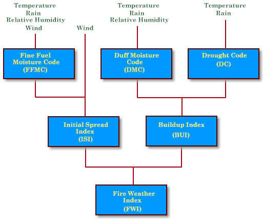
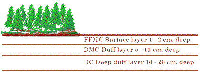
CFFDRS – FWI System
Alaska has used the Canadian Forest Fire Danger Rating System’s (CFFDRS) Fire Weather Index (FWI) system since 1992. Fire managers find it to be accurately representative of Alaska’s fuels and its fire season as a whole, as well as an excellent tool for predicting fuel conditions, including ignition and fire spread potential.
Descriptions and Definitions
This content is from https://fire.ak.blm.gov/predsvcs/fuelfire/fwidefined.php.
There is a network of approximately 175 weather stations, including both Remote Automatic Weather Stations (RAWS) and Federal Aviation Administration (FAA) weather stations that have been used to compute fire weather indices during this time frame. However, there are a number of other weather networks around the state that use different hardware and data feeds, which couldn’t easily be ingested into the existing Alaska fire data network. AKFF solves that data ingest issue and can now pull data and run calculations for many other weather station platforms. This has expanded the FWI network and filled many data holes around the state. AKFF also makes it easy for anyone with web access to get years of fire weather data and indices through a simple download interface.
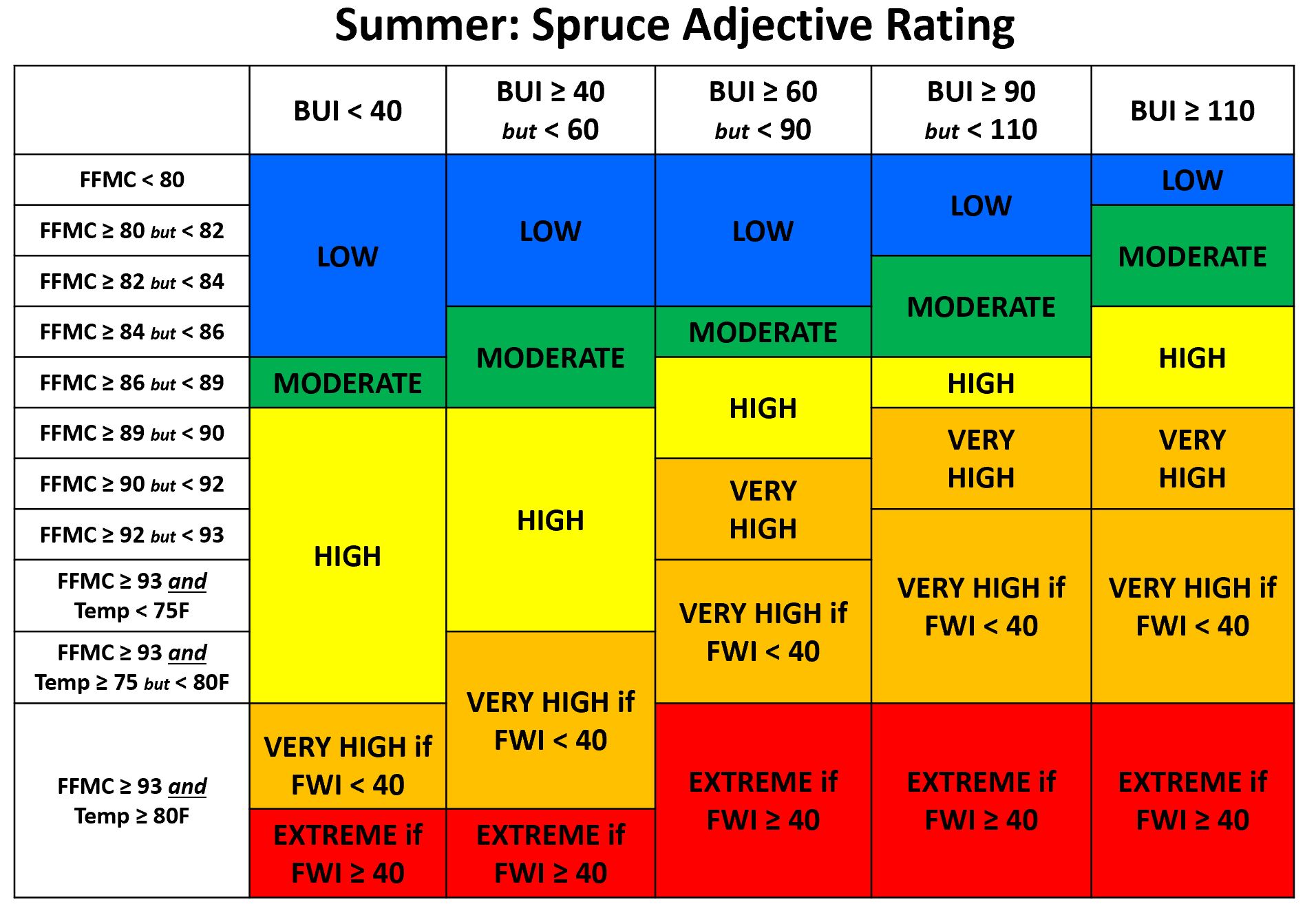
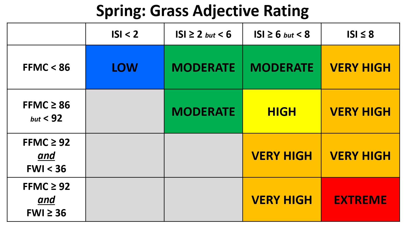
Fire Danger Ratings (Adjectives)
Fire managers use the fire weather indexes to understand the environment that is developing over time. To use these indexes, some relationships have been derived that combine thresholds of FWIs to characterize the overall risk for certain fuel types. The following are the decision matrixes that are used and displayed within AKFF:
AKFF Operational Details and Considerations
The following are descriptions of how AKFF works and creates the data resources we are making available.
Observational Data Collection
Observations are collected by MesoWest and SynopticLabs (MW/SL) through a variety of active push and pull procedures. These observations are made available to SynopticLabs' Mesonet API as quickly as possible. Observations are associated with the date, hour and minute that they are reported by the sensor.
AKFF uses Mesonet API to extract observations collected by MW/SL and put them into a rectangular database of observations for daily and hourly records. The daily values are collected as follows.
Active and inactive stations
Over time, a number of stations have come and gone from the system. While some stations are moved to a more appropriate location and given a name change, some simply no longer exist. Stations that are not expected to report this season, and perhaps ever again, are listed as INACTIVE. An inactive station is ignored by the observed and forecast processing systems, and serves only to provide metadata to data from prior years when the station had actively reported.
If a station is reporting or will report data during the current calendar year, it’s listed as ACTIVE. ACTIVE stations will have a new row inserted in the archive for every single day and hour of a calendar year in which they are listed as active. If no data are being reported from that station, then the inserted rows are empty for that station.
Daily Value Extraction Procedure
The daily observation of temperature (ATF), relative humidity (RHP) and wind speed (WSM) are taken from the last observation during the 2200 UTC hour. During the summer, this is equivalent to 1400 AKDT, and during the winter from the 1300 AKST hour. Since the last observation during the 2200 UTC hour is used, it means that the observation may be as late as 2259 UTC.
Precipitation values are the 24-hour integrated precipitation from the period of 2300 - 2259 UTC, representing the date that 2200 UTC falls on. These integrations are made by the MW/SL APIs, and are accomplished outside the AKFF system. Errors are known to exist in the precipitation integration procedures, many originate from discrepancies in type of reported precipitation, and that the tolerances are for computing the boundaries of an integration period.
Observations are downloaded for all ACTIVE stations for every day of the year.
Handling missing values
Stations miss values. It happens. Because FWIs require all 4 variables, in addition to prior day values, there are several procedures in place for missing values. In order of priority:
Missing temp/relh/wspd
- Try again later (unusually high latency)
- Try the earliest observation in 2300 UTC hour
- Try the observation stored in the hourly table for 2100 UTC
- Use the previous day's temperature (a persistence forecast)
Licenses, Credits and Acknowledgements
Most of the resources in AKFF do not require attribution, or, like the map, attribution is automatically included in the application itself. However, we do use some resources that require (or appreciate) acknowledgement, and those messages follow here.
Font Awesome by Dave Gandy - http://fontawesome.io
Our icon for marking fires on the map:
Icons made by Vectors Market from www.flaticon.com is licensed by CC 3.0 BY